FINAL BRIEFING


Just days away from the start: everything you need to know about El Cruce 2024
The Organizing Team is already in San Martín de los Andes, finalizing the last details. This edition will feature a record number of countries represented, as well as a record-breaking number of participants and international runners. Additionally, this year introduces La Etapa, with its start and finish set for December 1st at the Lácar Lake waterfront.
We hope you are training diligently to fully enjoy a ONE-OF-A-KIND experience. 75% of registered participants will be taking part in El Cruce for the first time. It’s important to understand that this is a UNIQUE race.
Discovering Patagonia is what defines us. Each edition, we strive to be original, creative, and adventurous, constantly evolving to provide a unique experience for all participants.
Come with the mindset of challenging yourselves over 3 days immersed in the mountains.
It is important to understand that the weather in Patagonia is unpredictable, and we will be exposed to whatever conditions we may face, while respecting nature and the mountains.
There are more than 1,000 people behind every detail of El Cruce, who, spread across all areas, make this the largest stage race in the world.

PACKET PICKUP: TWO-STEP PROCESS
We have implemented a two-step process to make accreditation more dynamic and efficient. If you have chosen to complete your accreditation in San Martín de los Andes, you must complete both steps. If you have already completed the early accreditation in Buenos Aires, Mar del Plata, or Bahía Blanca, you only need to complete step 1.
SCHEDULE FOR REGISTRATION IN SAN MARTÍN DE LOS ANDES
On November 25th, you will receive an email to reserve your appointment for both general registration and for those who only need to pick up their bib and bracelet after completing early registration in Buenos Aires, Mar del Plata, or Bahía Blanca.
EVENT SCHEDULE
Saturday, November 30 Inaugural Ceremony of El Cruce Saucony 2024 | Time 7:00 PM | Location: Lácar Lake Waterfront (Av. Costanera 900)
The day before your start Registration: Step 1. Hotel Le Village (Gral. Roca 816) Hours: 9:00 AM to 6:00 PM What do you pick up? Bib and bracelet. Runners who have already completed early registration in Buenos Aires, Mar del Plata, or Bahía Blanca only need to complete this step, in a fast lane.
Step 2: Club Lácar (Rivadavia 547) Hours: 9:00 AM to 6:30 PM What do you pick up? Official gear (bib, fleece, t-shirt, base layer, seamless neck gaiter). You will also find the Official El Cruce Store.
Camp Bag Drop THE DAY BEFORE THE RACE Location: Club Lácar (on Cnel. Rhode) Hours: 4:00 PM to 8:00 PM
Bag Check Service RACE DAY MORNING You can leave belongings that you won’t need at the camp or during the race. Each runner is allowed to drop off one backpack, carry-on, or suitcase. At the end of the third stage, you can pick up your bag from the same location where you left it. Location: Club Lácar Hours: 4:45 AM to 5:30 AM
STAGE ROUTES
It is important to note that the routes of all three stages will feature significant elevation gains, reaching around 2,000 meters above sea level. At this altitude, the wind and cold are felt intensely, especially on the ridgelines.
As every year, the Organization has mountain security personnel, doctors, and rescuers who, together with the race director, will determine the feasibility of completing each section of the race.
As we have clarified in previous instances, bad weather is a decisive factor that may trigger the activation of a plan B for the route.
Transfer to Stage 1 Start The transfer will be by buses departing from Club Lácar according to the starting groups. You will receive an email indicating which group you belong to, based on the time you provided in the registration form.
Trasnfer 1 - Arrive at Club Lácar by 5:00AM
Transfer 2 - Arrive at Club Lácar by 5:10AM
Transfer 3 - Arrive at Club Lácar by 5:15AM
Transfer 4 - Arrive at Club Lácar by 5:20AM
Transfer duration: 1 hour 40 minutes.
STAGE 1 ROUTE
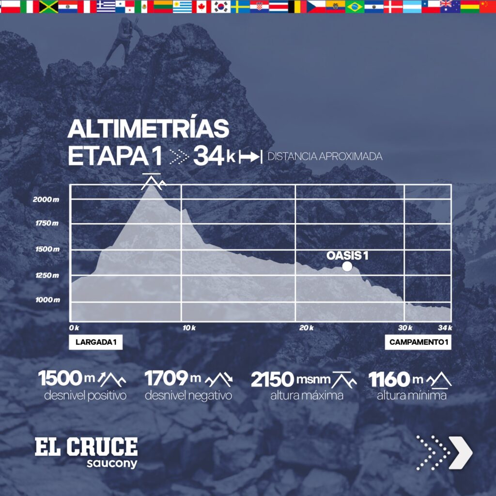
Distance: 34 km
Positive Elevation Gain: 1500 m
Negative Elevation Gain: : 1710 m
Number of Oasis: 1 | Kilometer 25
Cell Phone Signal: Not available
Each runner will receive a food kit for the route before boarding the bus that will take them to the start. It is important that you place these items in the zippered bag that you must carry in your race backpack, as they cannot be carried in their original packaging.
Remember the importance of not carrying wrappers in your backpack and not leaving any waste along the route.
The route will be marked with blue ribbons. You must follow these ribbons throughout the course, always looking for them ahead.
The start will be at Tromen, the base of Lanín Volcano.
FROM KILOMETER 1 TO 7
You will start at 1160 meters above sea level. It is very important to carry 2 liters of water in your backpacks. These will be 7 km of continuous ascent along the slope of Lanín Volcano. This is the toughest part of the route. Take it easy and enjoy the unparalleled landscape.
FROM KILOMETER 7 TO 10
At kilometer 7, you will begin a gentle descent along the southeast slope of the volcano towards the viewpoint of the Huelleytué Valley.
In these 3 kilometers, you will traverse heavy volcanic sand, which will slow your pace. A small ascent will bring you to kilometer 10.
This point offers an incredible view of Lanín and the Valley.
FROM KILOMETER 10 TO 24
From this point, you will cross rivers and streams with high-quality water.
These are 14 kilometers of descent along the eastern slope trail of the valley. An incredible landscape invites you to run, crossing rivers, always heading towards Huechulafquen Lake.
FROM KILOMETER 25 TO 34
At kilometer 25, you will find the Oasis with various drinks, salty snacks, sweets, and fruits.
From this point, you will continue the descent along mountain trails and paths to reach Camp 1 on the shore of Huechulafquen Lake.
During your stay at Camp 1, there will be no cell phone signal.
STAGE 2 ROUTE
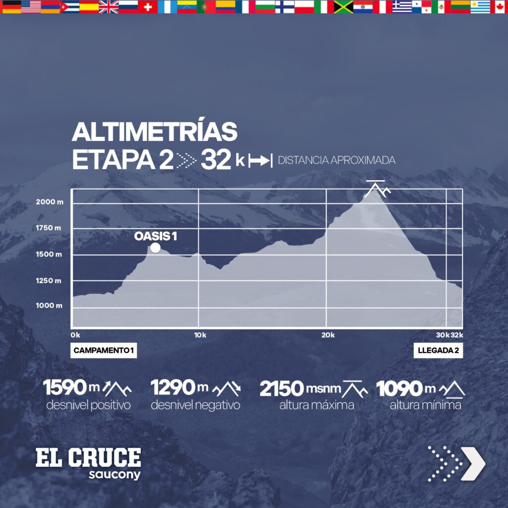
Distance: 32 km
Positive Elevation Gain: 1590 m
Negative Elevation Gain: : 1290 m
Number of Oasis: 1 | Kilometer 7
Cell Phone Signal: Not available
Stage 2 will begin at Camp 1. The start will be according to the overall arrival order of Stage 1. At the camp, you must approach the classification tent, where you will receive a ticket indicating your starting order. This ticket must be presented at the start of Stage 2, and the order will be sequential.
7:30 AM: From 1 to 100
7:33 AM: From 101 to 200
7:36 AM: From 201 to 300
7:39 AM: From 301 to 400
7:42 AM: From 401 to 500
7:45 AM: From 501 to 600
7:48 AM: From 601 to 700
7:51 AM: From 701 to 800
7:53 AM: From 801 to 900
7:55 AM: From 901 onwards
DESDE EL KILÓMETRO 1 al 7
Runners in primeros 4 kilómetros serán por camino de montaña. Luego seguirán por bosques hasta llegar al oasis en el kilómetro 7.
Si bien se encuentra a pocos kilómetros de la largada, será el único puesto que tendrán en esta etapa y por ello es importante que paren a abastecerse.
DESDE EL KILÓMETRO 7 al 21
Ingresarán en el Valle Hueyelthue recorrerán un sendero de la ladera opuesta a la Etapa 1. Serán 14 kilómetros de constante ascenso.
Cruzarán ríos y arroyos con vistas al volcán Lanín. Es importante que desde el kilómetro 18 carguen 2 litros de agua en los ríos y arroyos que cruzan para cuando se alejen del valle y pasen el bolsón para entrar a la ladera sureste del volcán.
DESDE EL KILÓMETRO 21 al 32
En este último tramo no tendrán ríos para abastecerse y estarán expuestos al sol, viento y/o diferentes condiciones climáticas sin lugar de reparo.
Recorrerán algunas sendas que les resultarán familiares ya que las atravesaron el día anterior. Hablamos de las que presentan arena volcánica. Se encontrarán, además, con importantes descensos que invitan a correr a un buen ritmo. En este punto, presten atención y cuiden sus rodillas. ¡Todavía queda un día más de carrera!
La llegada será en la base del volcán Lanín. Tendrán a disposición hidratación, snacks, sándwich, guiso y pastas instantáneas.
Una vez que lleguen, deberán subirse a los buses para que los trasladen al campamento 2. No se organicen para esperar a sus compañeros. Deberán salir enseguida porque el lugar no es apto para que haya demasiada gente al mismo tiempo.
Transfer duration to Camp 2: 1h 20 minutes, depending on traffic.
We have requested extreme caution from those in charge of the transfers.
During your stay at Camp 2, cell phone signal will be available.
STAGE 3 ROUTE
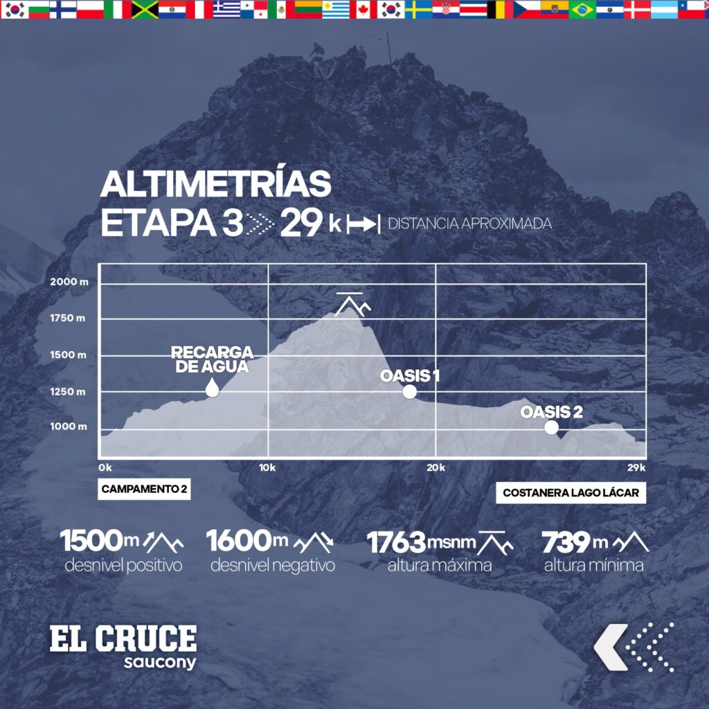
Distance: 29 km
Positive Elevation Gain: 1500 m
Negative Elevation Gain: : 1600 m
Number of Aid Stations: 1 | Kilometer 4 – Water Refil
Number of Oasis: 1 | Kilometers 16 and 23
Cell Phone Signal: Available at several points along the route
Stage 3 will begin from the camp according to the overall classification order from Day 1 and Day 2.
8:30 AM: From 1 to 100
8:35 AM: From 101 to 200
8:40 AM: From 201 to 300
8:45 AM: From 301 to 400
8:50 AM: From 401 to 500
8:55 AM: From 501 to 600
9:00 AM: From 601 to 700
9:10 AM: From 701 to 800
9:15 AM: From 801 to 900
9:20 AM: From 901 onwards
FROM KILOMETER 1 TO 5
The start of the final stage will be from Camp 2. From there until Kilometer 5, you will travel along mountain trails with a constant ascent, but not too steep. Many of these sections are suitable for running. Upon reaching Kilometer 5, you will find a water refill station.
FROM KILOMETER 5 TO 13
This will be a trail with a continuous ascent until reaching the summit of Cerro Colorado, with a positive elevation gain of 840 meters. The trail is sheltered by forest, except at the summit.
FROM KILOMETER 13 TO 16
You will encounter a constant descent from the mountain along very steep trails. Once again, take care of your knees on these downhill sections. After completing this segment, you will be able to recharge at the oasis.
FROM KILOMETER 13 UNTIL THE FINISH LINE
Now the descents will be more gradual, along mountain trails and paths, leading you towards the final finish line. You will find an oasis at kilometer 23, with a negative elevation drop of 450 meters.
The last 6 kilometers, if your legs hold up and the motivation is there, are very run-friendly.
In Stage 3, a classification system will be added, allowing your friends, family, or companions to track your progress in real time during the race. The system will provide an estimated race time so they can expect you at the finish line and enjoy that moment together.
The last 2 kilometers of the race offer unique views of the city of San Martín de los Andes and Lake Lácar. Because of this, we invite spectators to cheer and celebrate with the runners during the final stretch of the race.
FINAL FINISH LINE AT THE COSTANERA OF LAGO LÁCAR IN SAN MARTÍN DE LOS ANDES
MOUNTAIN SAFETY
All El Cruce participants should be aware that the race follows a mountainous route deep in the Andes on the slopes of Mount Lanín.
Although this is unique, we must be aware that it is not a simple course around a city.
In Stage 1, participants will have 25 kilometers with no escape routes and no way for a vehicle to access the trails they will be traveling.
Those who take more than 15 minutes per kilometer in the first stage will have an alternative route in Stage 2.
The regulation establishes that the time limits are 12 minutes per kilometer for group 1 and 14 minutes per kilometer for groups 2, 3, and 4. For this reason, those who take more than 15 minutes per kilometer in the first stage will NOT be able to follow the original route on day 2, as the Organization considers that, based on the time from the first stage, they will have more than 10 hours to complete the route of Stage 2. Due to the difficulty of evacuating people on the Lanín volcano, this decision is made with the safety of the runners in mind.
Those who take the alternative route in Stage 2 will be able to follow the original route of Stage 3.
They will be classified but will not be able to surpass the other participants who completed the entire original route.
Due to requests from communities and private fields, the maps will be provided 48 hours before the race. This request was made to prevent training or trail recognition on private properties through which the race passes.
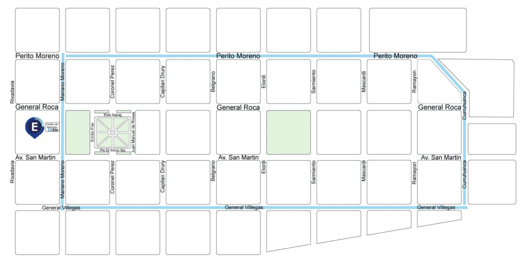
PARKING IN SAN MARTÍN DE LOS ANDES
The main streets of San Martín de los Andes have paid parking, so you can plan ahead by considering the hours and location for parking payment::
• Monday to Friday from 8:00 AM to 8:00 PM
• Saturdays from 8:00 AM to 1:00 PM
• Parking payment app: https://saemsmandes.com.ar/
YOUR MEMORIES OF THE WORLD'S LARGEST STAGE RACE
Our facial recognition system allows the identification of each runner, so you will have a large amount of material documenting your journey through El Cruce 2024. In addition, 30 photographers will be capturing everything that happens during the event, both before, during the camp days, and at the finish line, as well as after the race.
You will find the most beautiful memories of your journey through the Senderos del Lanín at FotoRun.


DOWNLOAD YOUR LOGO
Use the El Cruce logo for your clothing, personal items, and also share it with your Running Team. You can download it from this link in various formats, so you have access to the file in the quality you need.
SPONSORED BY


